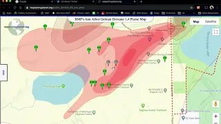
This map has all the monitoring wells, extraction wells, treatment ponds, residential wells and the Prohibition Zone Boundary of 2011. RMP will be updating this map to the newer Rockwell data commissioned by EGLE.
Short soundless video demonstrating how to use RMP's interactive map to zoom in and see the treatment ponds where the Gelman 1,4 Dioxane plume was started. Follow these same steps yourself by launching the map. Once you learn to navigate RMP's maps, you'll be hooked.
Publish Date: Feb 26, 2020
Duration: 1:09
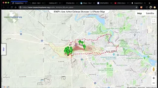
This video goes over the basics of how to use the map such as hiding/unhiding markers and understanding the different types of markers. Watch this video to learn how to interact with the map and see the gigabytes of underlying data you can drill into. This video was made when RMP launched it's Gen2 map of the Gelman 1,4 Dioxane Plume with a slide out control panel. RMP's Gen3 map will show municipal water intake, A2's water treatment center, and Honey Creek.
Publish Date: Jun 30, 2019
Duration: 8:25
This instructional article explains how to use the features of RMP's GEN2 Dioxane 1,4 Map. Learn the basics of interactivity in terms of turning on/off marker features. Locate the treatment ponds (epicenter), extraction wells, and monitoring wells. See the plume key. RMP's Gen2 map added the slide out control panel. Gen3 map will build on that and add more features. Gen3 map coming in 2024.
Publish Date: Jun 30, 2019
Read Time: 20 minutes
This article introduces RMP's first Gelman Dioxane 1,4 map in Ann Arbor. The map introduced in this article shows how far RMP has come with its mapping software. This map was just an image overlay pinned down to a Google Map. It was still way cooler than pdf file which is all that existed at the time on the internet with the exception of Scio Residents for Safe Water who had a pretty good map that I was not aware of as I was working on this first map.
Publish Date: May 1, 2016
Read Time: 2 minutes