
Five years after the Enbridge Energy Line 6B oil spill into the Kalamazoo River, we reflect on its impact and contemplate our use of oil as an energy source. While this post is a couple months past the official 5 year anniversary of the spill, it’s a fitting time for RMP to talk about this event as Toyota’s Fuel Cell Electric Vehicle (FCEV) the Mirai will be hitting the shores of California within one month from the publishing date of this article. RMP continues to cheerlead talk about FCEVs like the Mirai because they render the use of oil as an energy source as technologically obsolete even if gasoline might be around for years to come. For less money than we spend on military operations to protect oil infrastructure and strategic maritime choke points in the Middle East, we can build a hydrogen fueling infrastructure that supports the transportation sector of our economy for future generations without the use of crude oil. By using crude oil for energy we: send millions of dollars each day to countries that financially support Jihad against America, cope with infrastructure all across our land that threatens and contaminates drinking water sources, and unnecessarily depend on a commodity that is the number one culprit of an 11% import/export deficit on the US economy.
Despite TV commercials funded by the API and IPAA, America does not have enough oil to meet its needs to support our transportation sector demands for energy; in fact, the US can only meet roughly 50% of our oil needs at the current production rates, which in 2015 are the highest in the last 40 years. America has enough coal and natural gas to power 100% or our energy needs while reducing greenhouse emissions and threats to ground water and air emissions as we transition toward renewable energy sources like solar, wind, and garbage. RMP writes about, and will continue to write about, the responsible migration away from oil as an energy source for the good of our economy and national security.
As we take a look back at the Kalamazoo Oil Spill we contemplate two major points of interest: 1) the cost of the cleanup which is the highest in US history at $1.2 billion dollars, and 2) where the costs of cleanup would fall had Enbridge been bankrupted by the event. Big events like the Kalamazoo oil spill grab headlines because of the size and visual impact they create. But other events, every day events, like the leaking storage tanks at the gas stations where you fill up your car each week are where the real story of oil contamination costs lie, and those every day realities that seldom generate a headline have numbed us into complacency.
There are more than 41,000 underground petroleum storage tanks (i.e. Gas Stations) listed in Michigan alone. Nearly 10,000 of these storage tanks leak and threaten, or in fact contaminate ground water throughout our state. It’s truly these smaller and collective impacts where the financial costs of oil are a triple burden to taxpayers: We pay for gasoline to fuel our cars, we pay for our military to protect crude oil assets in hostile countries, then we pay again for the cleanup of leaking petroleum storage tanks and pipeline spills. All of these costs can be phased out if we move away from oil as an energy source.
RMP will continue to use the data we collect and analyze to highlight how oil is detrimental to America’s economy and our national security. RMP will give credit where credit is due and we applaud Enbridge for embracing and investing in fuel cell technologies like their 1.2 MW ultra clean power plant in Toronto that captures energy that would otherwise be wasted. It is a bold step to see an oil company invest in technology that will in fact render oil to antiquity as an energy source one day.
As fuel cells grow in popularity as a means to replace oil as an energy source, we must be especially careful how we hold money in escrow for spills and environmental remediation. Oil companies that do not adapt to smarter energy technologies will financially weaken as time goes by. When these stubborn and weakened companies are faced with an environmental disaster, it could bankrupt them. If an oil company, particularly a pipeline company, goes bankrupt as a result of a major spill, the costs and risks associated with the cleanup will become the burden of the taxpayers. Keep these common sense thoughts in mind when you read the next paragraphs and think about what kind of companies can withstand a $1.2 billion dollar hit and continue to carry on.
Information and text in the summary of the Kalamazoo Oil Spill below is excerpted from the Enbridge Line 6B MP 608 Marshall, MI Pipeline Release Draft No Further Action Report prepared by Enbridge Energy for the MDEQ.
Summary of the Kalamazoo River Oil Spill
On July 26, 2010, Enbridge Energy, Limited Partnership (Enbridge) discovered a release of crude oil from the pipeline owned by Enbridge that runs just south of Marshall, Michigan (Line 6B) in the vicinity of a pump station. The Line 6B crude oil was released below grade level via a break in Line 6B at Mile Post (MP) 608, emerged onto the ground surface, flowed over land following the natural topography into Talmadge Creek.
The Line 6B crude oil flowed down Talmadge Creek to the confluence with the Kalamazoo River. At this time Talmadge Creek discharge was higher than normal due to recent heavy precipitation and in many areas the river had overflowed its banks. This resulted in the Line 6B crude oil affecting floodplain areas on both sides of the creek and Line 6B crude oil deposits were observed in floodplain areas including the shoreline, banks, and low-lying overbank areas. As water levels in the river receded, much of the Line 6B crude oil flowed with the flooded water back within the banks of the Kalamazoo River; however, some Line 6B crude oil became stranded in hydrologically isolated topographic depressions, cavities, burrows, and other traps within the flooded areas.
A substantial amount of Line 6B crude oil was recovered via boom, vacuum surface pumping, and extensive excavation within the Source Area and along Talmadge Creek. The remaining crude oil gradually adhered to sediment particles and was suspended within the water column at turbulent flows over dam spillways. The suspended material settled in natural depositional areas within the river channel, becoming submerged oil. Line 6B crude oil was transported downstream to and along the Kalamazoo River as far as the delta at Morrow Lake on the Kalamazoo River near Kalamazoo, Michigan.
Following the release, Enbridge performed response activities under the direction of the United States Environmental Protection Agency (U.S. EPA) and the Michigan Department of Environmental Quality (MDEQ) to remove Line 6B crude oil from the river system and to respond to the release
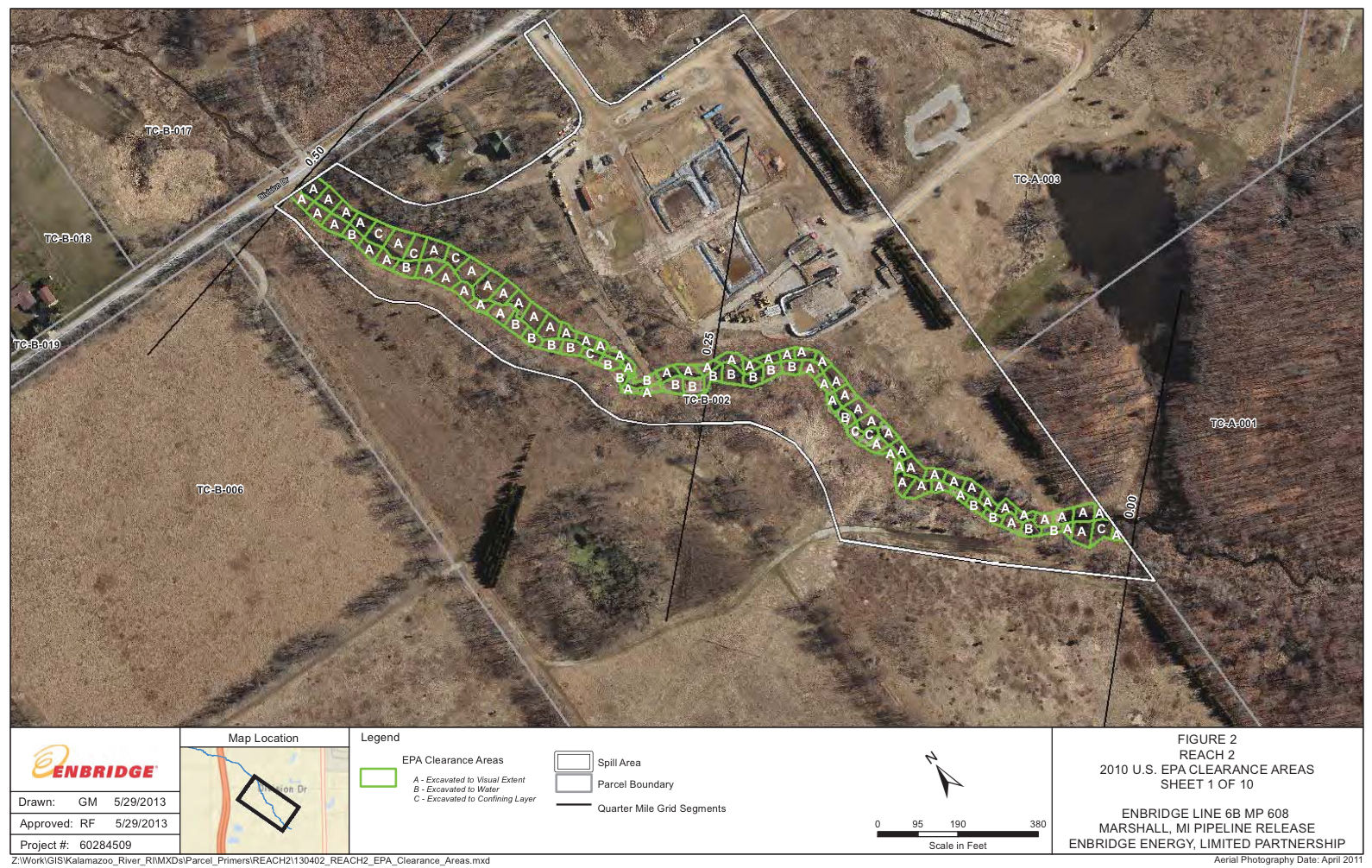
During 2010 emergency response activities included excavation of visually impacted sediments and soils from areas adjacent to Talmadge Creek in accordance with the Source Area Response Plan (SAR) approved by the U.S. EPA on August 19, 2010 and Supplemental Source Area Response Plan (SSAR) approved by the U.S. EPA on October 17, 2010. The Talmadge Creek streambed was not excavated in 2010. Prior to excavation of the overbank soils, coir logs were placed adjacent to the creek bank to stabilize and preserve the creek bed. After excavation was completed, clean fill was used to replace the excavated sediments and erosion control blankets were placed over the fill materials to help stabilize the wetland areas.
Upon completion of the excavation an investigation was performed by demarcating both banks of the creek into 50-foot sections and then independently evaluating each section for the presence of oil and/or oil sheen. Test pits were excavated to assess the presence of oil and/or oil sheen. If oil and/or oil sheen were present, additional excavation was conducted in that section.
Nature & Extent of Contamination
The remedy for the first half mile of Talmadge Creek was excavation of the entire creek channel and portions of the adjacent wetland. A total of 219 surface soil samples were collected and analyzed from the initial Soil Staging Area. A total of 10 soil samples at 5 areas from the initial Soil Staging Area had concentrations of VOCs, which exceeded the Part 201 Soil Criteria. Eight of the ten concentrations were for tetrahydrofuran, which were at concentrations in excess of the Part 201 DWPC; however, tetrahydrofuran is manufactured (for example, Weissermel and Arpe, 1997), not naturally occurring, not detected in the Line 6B crude oil, and therefore is not considered a Line 6B crude oil-related parameter. These soil samples were removed during the subsequent excavations. This indicates contaminants from other sources (i.e. not from Line 6B) were present above Part 201 criteria in Talmadge Creek before the oil spill.
To define the nature and extent of in-stream impacts, poling of Talmadge Creek in the Spill Area was conducted during the Remedial Investigation in accordance with the Sediment Poling Standard Operating Procedure submitted to U.S. EPA May 11, 2012. Poling generally involves the measurement of sediment and water characteristics using specialized tooling designed for the task. Specific field conditions such as location, water depth and temperature, sediment thickness and temperature, and a qualitative determination of oil sheen and globule coverage over a specified surface area are recorded.
Water depth (i.e. depth to sediment surface) was the first measurement at each poling location. To measure water depth, a 6-inch diameter disk was attached to the end of a pole graduated with 0.1-foot intervals. The pole was gradually lowered to the top of the sediment bed. Next, the thickness of soft sediment was measured. A pole without a disk (approximately 2 inches in diameter) with maximum graduations of 0.1 feet was pushed vertically through the sediment until advancement was restricted. The depth to sediment surface (water depth) and maximum poling depth into the soft sediment determined the soft sediment thickness at each location.
A pole with a 6-inch diameter disk attached at the base was used to agitate the soft sediment to determine the amount of submerged oil at each location. The degree of oil observed at the water surface after agitation was described using four categories including heavy, moderate, light, or none. Areas of ‘heavy’ to ‘moderate’ oil were more prevalent from MP 0.00 to MP 0.25 than downstream from MP 0.25 to MP 0.50. All sediment including the sediments associated with these poling results were subsequently excavated in 2011 and verification soil samples were collected from the bottom and sides of the excavation.
A total of 47 sediment samples were collected from Talmadge Creek. Sediment concentrations did not exceed the Ecological Screening Levels except for concentrations of arsenic; however, arsenic was not detected in the Line 6B crude oil from the release and is not considered a Line 6B oil-related parameter. All sediments were excavated during the 2011 excavation activities. Sample locations (including the Submerged Oil Task Force (SOTF) samples), split samples, and exceedances of the U.S. EPA Region 5 Ecological Screening.

Field observations were noted for soil cores with no oil observed by the field team or the logging team, oil observed by the field team but not the logging team, trace fluorescence, and oil fluorescence observed. It was presumed that areas where oil fluorescence was observed would be excavated and therefore, no samples for subsequent laboratory analysis were collected from these areas. To define the extent of the proposed excavation, cores were advanced laterally in areas where impact was observed until no impact was noted in the cores.
The entire creek bed, all coir logs that had been installed in 2010 during the interim restoration along the creek bank, and visually impacted portions of the overbank observed during the Remedial Investigation were excavated in the fall of 2011 based on the fluorescence in the soil cores. A total of 9,772 cubic yards of soil and sediment were excavated over an area of 71,849 square feet.
Conclusion & Take Away
The Enbridge Line 6B oil spill was an unfortunate event for all involved. Oil spills like this are an inherent risk as long as we continue to use crude oil as an energy source. According to Enbridge Energy’s last 3 quarterly financial reports (i.e. their 10Q statements – the September 2015 10Q is not yet available at this publishing date), the final costs of the spill are estimated to be at $1.2 billion and are representative of the largest inland oil spill in US history. In a perverted way, we are lucky in the sense that Enbridge was financially healthy enough to bear the burden of these cleanup costs or they would ultimately fall to the US taxpayer.
If you drive in a car, ride on a bus, ride on an airplane, use a smart phone, or are reading this on a computer, you play a part in why there are millions of gallons of oil consumed each day in America and around the world. We now have the technology to begin to phase out oil as an energy source to begin a migration away from an energy source that threatens our environment and national security. Calls for expansion of oil infrastructure like the Keystone XL pipeline, oil exports, and Arctic drilling go against common sense and delay the inevitable end to oil as an energy source in the coming decades. Acting now to decommission certain pipelines like Line 5 under the Straits of Mackinac can save us potentially billions of dollars and aggravation should there ever be a pipeline rupture in such a sensitive area of such a valuable natural resource like our Great Lakes.
You can help hasten the migration away from oil as an energy source by supporting the adoption of Fuel Cell Electric Vehicles. FCEVs can be powered from anything, including water via solar & wind.
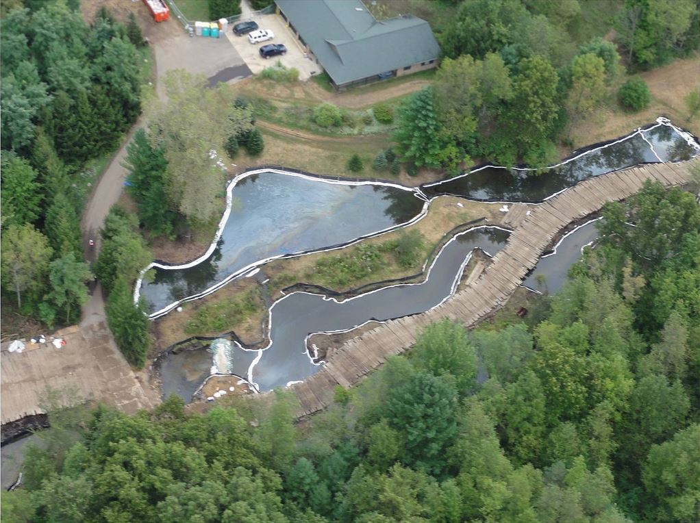
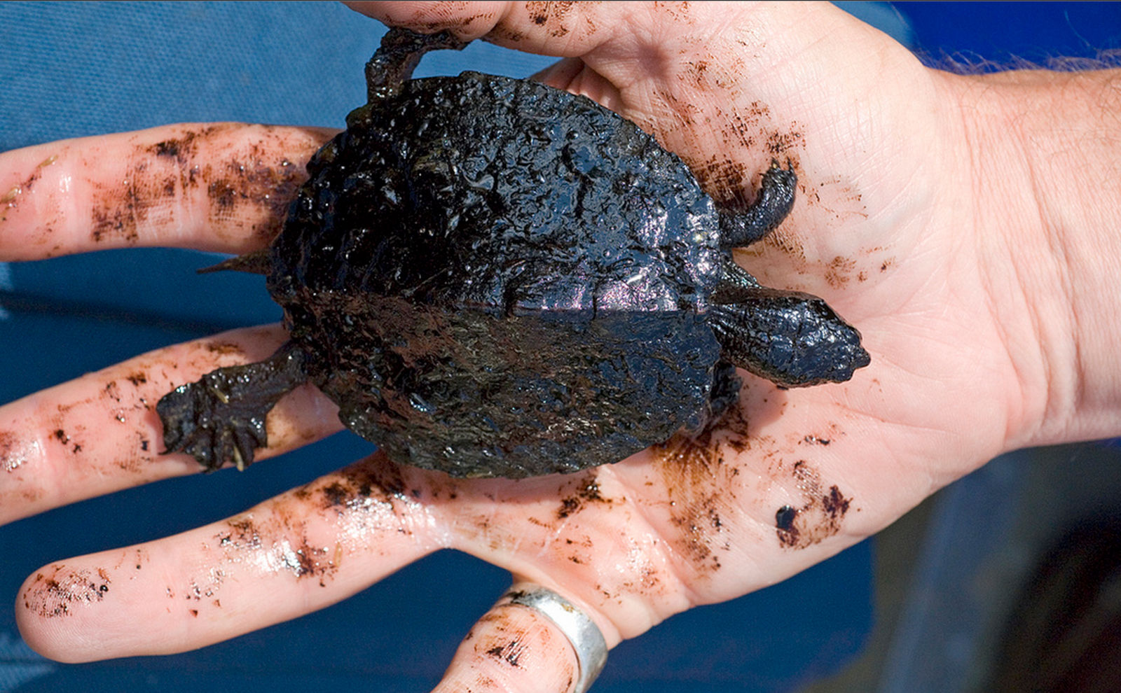
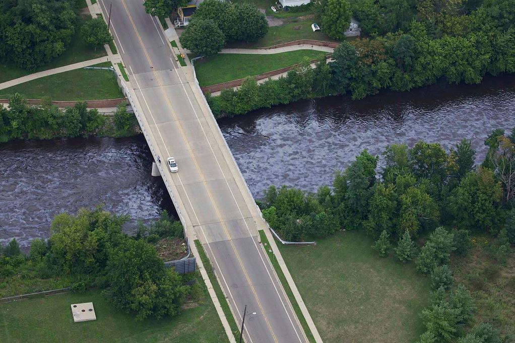
Kalamazoo Oil Spill Picture Gallery:
Take a look through some of the pictures we’ve accumulated from the MDEQ in the gallery below. Click on any of the thumbnails below and you’ll open a gallery. Click on the left or right side of the image to scroll through all the photos.


Leave a Reply