
RMP Update 5/18/2022 – RMP’s interactive contamination map of Wurtsmith AFB at the bottom of this story has been temporarily taken down. RMP is always upgrading our Made In Michigan mapping software. We are currently in the process of upgrading old maps to our version 3 software. A new and improved map of Wurtsmith AFB will be published soon. Stay tuned. Still a great story below even 6 years after original publication. Enjoy the rest of the story.
The Detroit Free Press published an article March 10, 2016 written by Keith Matheny that raises awareness about groundwater contamination at Wurtsmith Air Force Base (WAFB) in Oscoda, Michigan. You can read the Freep article by clicking here. Keith’s article has current information and details about an upcoming “open house” being held by the MDEQ & US Air Force on March 23, 2016 in Oscoda in order to brief the public about groundwater contamination at WAFB. Each day thousands of gallons of Pure Michigan freshwater soak through Landfill #27 and become contaminated water that flows south through Clark’s Marsh to the Au Sable River and then out to Lake Huron. The extent of the contamination plume around WAFB is not fully understood but ongoing studies are underway to delineate the pollution. A “do not eat” fish advisory was issued immediately after data first became available on May 2, 2012 that showed contamination levels at WAFB above GSI criteria. It’s great to see Freep covering issues that raise awareness about important contamination “hot spots” in the Michigan Basin. RMP has been working on a list of contaminated hot spots in Michigan and WAFB is on our top 10 list. In this post, I will write a little bit about
: environmental issues surrounding former Landfill #27 at the decommissioned Air Force base, a remedial investigation performed by San Francisco based URS that was commissioned by the Air Force and published September 2012, and the MDEQ’s current concerns with the former landfill and the URS report.

RMP is a small Michigan environmental 501(c)3 organization that makes maps using advanced JavaScript and PHP. At the end of this short post [scroll all the way down] about Wurtsmith, RMP has included an example map that is just the tip of the iceberg of what RMP can do using the Google Maps API v3. RMP’s Wurtsmith map shows all monitoring wells and their respective contamination levels from the URS 2012 study. RMP can graft overlays, add opacity sliders, call up shapedata overlays from 100s of REST servers around the world, and add many other controls to a Google Map to make it an extraordinarily powerful tool for studying environmental sciences. What really separates RMP’s software from other sites on the World Wide Web, however, is the fact that our software connects the points, polylines, and polygons you see on the map to an SQL database using PHP. By connecting to an SQL database through interactive Google Maps using JavaScript, RMP can file terabytes of data very smartly with our exclusive geospatial filing technology. The best example of our searchable mapping technology is our www.respectmyplanet.org homepage where over 20,000 unique visitors have searched our interactive oil, gas, & disposal wells map that shows location & production information for all of Michigan’s nearly 65,000 oil, gas, and disposal wells. Our Michigan made software allows data to be accessed and updated by the general public in real time and will always be free of charge to anyone with an internet connection. Because our organization is small and relies only on very limited part-time volunteer labor, we can only afford to make demonstration maps that show a glimpse of what we could do if we had funding. If you would like to help kick-start a truly grass roots Michigan based 501(c)3 environmental organization, please consider making a small tax deductible donation by clicking here. Together we can build out an amazing library of powerful Google Maps that will allow educators, students, scientists, first responders, and the general public to interact with data that can move environmental remediation science forward like never before seen. Now on with the story about Wurtsmith Air Force Base…
Wurtsmith Air Force Base (WAFB) Background Information
From its humble beginnings in the 1920’s as an aircraft gunnery range, to its status a vital member of America’s strategic defense, Wurtsmith Air Force Base has distinguished itself as an important part of our country’s military history. Throughout WAFB’s history, environmental sciences were not understood or contemplated like they are today, and for many years the focus at Wurtsmith was keeping America safe from our enemies rather than focusing on safe disposal of toxic wastes. From 1924 to 1944, army pilots would fly their winter maneuvers from WAFB to Selfridge AFB near Detroit. In many of those years, through the snow squalls and winter winds, oil drums were heated over open fires at WAFB. The ground crews would quickly take the barrels of hot oil over to the airplanes and it would be poured into the engines. The ground crews would quickly hand-crank the engines to try to get them started before the oil cooled and congealed. Gasoline to fuel the planes was hauled across the ice-covered Van Etten Lake on six-foot hand sleds two barrels at a time.

WAFB is probably best known and remembered by many Michiganders, however, for its Boeing B-52H bombers stationed there through the 1960’s to the 1980’s. In May of 1961, WAFB took delivery of its first B-52H Stratofortress called the “State of Michigan”. Boeing’s B-52H’s were the latest and the fastest of the B52s and had a combat range of 4,176 miles with a bomb payload of 10,000 lbs. Retirement of the B52s began in the late 1980’s but was delayed during the Gulf War of 1990-91. Wurtsmith stationed B52’s were deployed to the King Abdul Aziz Air Base in Dhahran, Saudi Arabia in 1990 to help push Saddam Hussein out of Kuwait. RMP writes often about Saudi Arabia and King Salman, the most powerful and influential man in the world with regard to crude oil production.
WAFB was closed on June 30, 1993 after the 1991 Base Realignment And Closure Act (BRAC). On December 15, of 1992, the last B-52 Bomber called “The Old Crow Express” set flight for Davis-Monthan Air Force Base for storage. RMP is thankful for the men and women who served our country at WAFB and fought for our freedom through WWII, Vietnam, and The Gulf War. Now that WAFB has been decommissioned, however, environmental scientists have a new war to fight: we have a war to wage on legacy contamination because of toxic chemicals coming in contact with our freshwater. Modern warfare is changing. The art of war is the most complex and noble of all the arts. Some important battle fronts developing in modern warfare include sustainable energy production and computer hacking. RMP understands how sustainable energy production and decentralizing our grid makes America a safer place for generations to come while protecting our freshwater. Everything in the new age of warfare fits in with how we protect our water; our most valuable natural resource.
RMP keeps beating the drum on the two major concerns with regard to environmental contamination in Michigan that don’t seem to register much media coverage: landfills & storage tanks. Landfills and storage tanks have caused and continue to cause significant environmental damage in Michigan and in other states. RMP supports fuel cells and gasification technology in every post we write as a solution to mitigate water contamination and provide sustainable energy. By switching to H2 & fuel cells we can eliminate landfills and storage tanks of toxic substances. Sustainable energy production to protect freshwater is the core of RMP’s mission. Instead of calling things “waste”, we have the technology to turn “waste” into sustainable fuel with little environmental impact while eliminating imports of fossil fuels. Instead of burying toxic material on top of our drinking water, we can eliminate it by turning it into clean energy.
Landfill #27 at WAFB
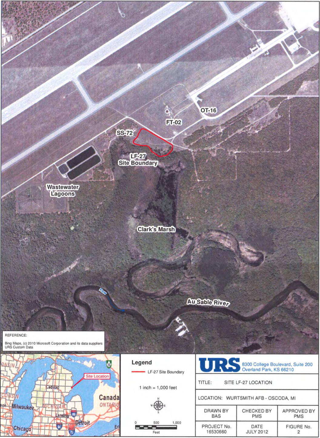
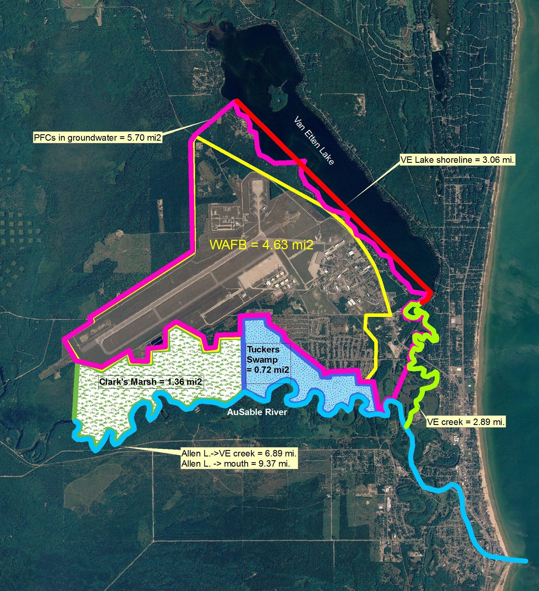
WAFB occupies 5,221 acres and is located 170 miles north of Detroit in Iosco County, in northeast Michigan, west of Lake Huron and just on the north side of the Au Sable River (see interactive map at bottom of this post). The former landfill LF-27 encloses about 6 ½ acres and is located in the south central part of the base. The landfill operated between 1950 and 1972 and accepted coal ash (from the base power plant) and demolition/construction wastes. Landfill #27 extended south into Clark’s Marsh, which lies between WAFB and northern bank of the Au Sable River. Groundwater from Landfill #27 discharges to Clark’s Marsh surface water; this surface water then meanders through Clark’s Marsh to the Au Sable River and then flows out to Lake Huron. Dissolved levels of ammonia and manganese in this ground water exceed ecological regulatory levels.
The USGS performed the first ecological survey of this landfill in 1990. The Air Force followed up by hiring a consultant firm, ICF Technology, to perform a more refined geophysical investigation as well as extensive groundwater, soil, surface water, and sediment sampling. Data was reported by ICF in 1997. Included in the 1997 comprehensive report was a Human Health Risk as well as an Ecological Risk Assessment. Air Force consultant URS performed a 2008 direct push investigation to delineate manganese in the ground water. URS performed a direct push investigation in 2011 to delineate ammonia in ground water. URS also performed investigations in 2002, 2008, and 2012. Groundwater monitoring began in 1998 and continues today.
At (LF)-27 manganese and ammonia levels in groundwater exceed their respective groundwater/surface water interface (GSI) criteria. In Clark’s Marsh, surface water exceedances of both manganese and ammonia have been recorded down gradient of (LF)-27. Dissolved Oxygen levels in Clark’s Marsh do not support aquatic life. Issues of environmental remediation in this area center around:
- Manganese and ammonia exceeding GSI levels in groundwater
- Iron staining due to oxidation, and
- Presence of methane which is a safety issue during intrusive investigations
Disposal in (LF)-27 ceased in 1972 and has left behind the footprint of environmental damage in Michigan that we have today. According to the URS report’s executive summary published in September of 2012, biodegradable material in the landfill has decomposed forming organic acids that are believed to be responsible for the pH level dropping from 7 to 6 liberating manganese and iron. These two elements can also be reduced to soluble forms when they function as electron acceptors during biodegradation. Ammonia is generated by biodegradation of organic nitrogen such as that found in sewage sludge. The bulk of the groundwater contamination appears to be cause by buried waste. URS estimates that roughly 11,250 gallons of contaminated water per day drains through (LF)-27 to Clark’s Marsh, to the Au Sable, and then out to Lake Huron although there is no way to truly measure such numbers or to quantify the impacts. Further, the information in this paragraph is contradictory to other information in the URS report as explained below.
Dale Corsi from AECOM, the parent company of URS, reviewed the URS report and pointed out some inconsistencies in an email he sent to the MDEQ on January 11, 2013. Here are some of Dale’s points and questions regarding the URS report laid out in his email:
The Executive Summary discusses ecological impacts. The first bullet states that chronic toxicity tests conducted in 2003 with surface waters from the seeps at LF‐27 did not indicate toxicity. The MDEQ approved those tests, however the discharging groundwater is anoxic, and contains manganese and ammonia at concentrations above the FAV, (i.e., levels toxic to aquatic life). The test procedure oxygenates the water, which would oxidize the dissolved manganese to an insoluble form and the ammonia to nitrate which is less toxic than ammonia. Therefore the test does not accurately measure the toxicity of these compounds.
The Executive Summary briefly discusses the Conceptual Site Model (CSM) and states that there is an estimated 11, 250 gallons per day of impacted groundwater (manganese and ammonia greater than the respective (FAV). This statement is based on calculations presented in Section 4 (page 4‐2), which states: “A plume flux front of 1,000 square feet (500 foot length x 20 foot height) was estimated using Figure 5b.” The arithmetic in this statement is incorrect – 500 feet times 20 feet equals 10,000 square feet. This then translates to a flux volume of 112,200 gallons per day discharging into Clark’s Marsh (ten times higher than the 11,500 gallons per day stated in the document). Section 4 continues to state that quantifiable, negative impacts have not been observed in the marsh. This statement is not accurate. As stated in the Executive Summary and in Section 1.8, there is a zone of the marsh adjacent to the discharge that cannot support macroinvertebrates. This zone is anthropogenic, being caused by the discharge of anoxic water into the marsh, which is a direct result of the fill material in the landfill consuming the oxygen in the upgradient water as it moves through the landfill to the marsh.
In the Executive Summary conclusions (2), it is stated that “Ecological demonstrations conducted over the last 10 years indicate no quantifiable impacts other than the observations of several areas of precipitated iron (i.e., yellow boy).” The region of low DO adjacent to the marsh is considered by the State to be an area of ecological impact because the area of impact cannot support macroinvertebrates.
Throughout the document [Sept 2012 URS report] there are statements that ammonia and methane are generated by the anaerobic and/or aerobic degradation/decay. Have materials been identified that are known to have been degrading/decaying? Section 4 states that ammonia is a “by-product of biodegradation of proteins containing organic nitrogen such as those found in sewage sludge.” Is there any evidence that the landfill contains sewage sludge? If not, are there any reports of something that was possibly put in the landfill that could be the source of the organic nitrogen compounds to be the source of ammonia? Similarly, what evidence is there for materials that could be degrading into methane?
The ecological risk assessment does not consider the effect of bio‐accumulating compounds, specifically Data has been generated that shows extremely high concentrations of PFCs in Clark’s Marsh fish. These concentrations were so high that Michigan Department of Community Health issued fish advisories immediately after receiving the data on May 2, 2012. Samples collected (by MDEQ) during the December 2011 investigation indicate elevated levels of PFCs in the groundwater, ranging from about 280 ppt (LF27 GP25) to 3,900 ppt (LF27 GP31).
Subsequent to AECOM’s review of the URS report, Robert Delaney issued Michigan’s MDEQ concerns in a February 2014 email to Air Force personnel with carbon copies to folks at AECOM, the US EPA, and others within the MDEQ. Bob’s email reads as follows:
Dave and Paul,
Below are MDEQ’s comments on the Draft Final LF‐27 Remedial Investigation Report submitted by URS and dated September 2012. There are three significant issues with the report. First, using the facts that the landfill has created anaerobic conditions in the marsh and those conditions have eliminated macro invertebrates from the discharge area, to minimize the risks posed by the toxicity of materials discharged to the wetland, is not acceptable. The site is generating conditions that are destructive to the environment in numerous ways and those conditions don’t cancel each other.
Secondly, the RI did not really address the methane issue. There will need to be a remedial action to address this condition, even if that action were just deed restrictions and a permanent marker. Something must be done to eliminate or manage the risks. The RI should cover this subject adequately and addressing the problem should be part of a feasibility study.
Finally, any ecological risk analysis, or any risk assessment that is done on this site must now include PFC contamination. Breaking out the PFC issues on sites that are already at the RA stage was excepted as the practical way to proceed. But all new site decisions and RODs will need to account for PFC contamination. Remedies, if they are needed, must be coordinated in such a way as to address all risk pathways and contaminants.
It is acceptable to state that a supplemental RI is needed before a final risk assessment and feasibility study can be performed in support of a final ROD. But it would not be acceptable to final this study as if the work were complete.
Thank you for the opportunity to comment. Bob
Robert Delaney DSMOA Coordinator Department of Environmental Quality
Conclusion
At this point, there appears to be much work ahead to remediate the environmental concerns at WAFB. RMP has been posting short informational posts like this one to accomplish two things:
- RMP is trying to raise awareness about environmental contamination hot spots throughout the Michigan Basin that seem to be outside of the general public’s radar.
- RMP is also trying to showcase the power of our Michigan made mapping software and its potential to bring important environemental information to the general public.

RMP has a particular interest in reporting on environmental contamination caused by landfills because we advocate for using landfill waste as clean sustainable energy using modern gasification technology. New legislation (HB 4297) is working it’s way through Michigan’s State Legislature and has passed committee with strong bi-partisan support according to an email I recently received from the bill’s sponsor Aric Nesbitt. HB 4297 incentivizes electricity generation from plasma arc gasification technology. If that sounds cryptic, it basically means all types typical landfill waste, including hazardous materials but excluding radioactive wastes, can be thermally decomposed into synthetic naturals gas with no NOx pollution, no SOx pollution, no CO2 emitted to atmosphere, and the only solid by-product of the process is vitrified glass that is 100% inert and can be used to make roads and concrete. Imagine if Michigan could quickly embrace the construction of new waste processing facilities that could divert landfill waste in order to create energy and create jobs. RMP imagines sustainable energy every day, it’s what we do. Fuel cells and Plasma Arc Gasification technology can make sure there is never another Landfill #27 or any other landfill.
RMP’s Wurtsmith AFB Map
RMP has acquired the 769 page WAFB remedial investigation report prepared by URS for the Air Force that was published September 2012 to bring you much of the information in this report. It is from this report that RMP obtained many megabytes of information that we could weave into our interactive Google Map if we could find funding.
The map shown below (scroll down) is just an example of what RMP can do with mapping environmental data. The map below is a called a “ground overlay” and is a large image file grafted to a Google Map showing all monitoring wells at WAFB. You can zoom in and zoom out to get a closer look at the GW monitoring wells and there is a legend key on the right side of the image. This map is not optimized for mobile but it could be. RMP can turn each and every monitoring well into a data repository with real data. We can group monitoring wells, show multiple different overlays, and give locations their own homepage like a facebook page for a location. You will not find maps like RMP’s anywhere else on the internet because the software was written right here in Michigan and is exclusive to our website. Only you can help unleash the power of RMP’s mapping technology onto the Internet by making asmall tax-deductible donation. Thanks for your support and thanks for reading.
Wurtsmith Air Force Base Map
Update 6/28/2025 – The Wurtsmith Map has been taken down temporarily. It will be back as an RMP V3 software map soon. RMP’s mapping software has evolved over 15 years. This map is about to get some new shoes.
Leave a Reply